

Drone Complier - Drone app for DJI, sUAS & pilots

Drone Complier - Drone app for DJI, sUAS & pilots का विवरण
Drone Complier – the most useful, intuitive and intelligent drone management software available, built by pilots, for pilots.
Use this cross-platform solution to instantly check airspace and weather, plan flights, manage aircraft, batteries and pilots, and make sure you are complying with local regulations and documentation requirements.
Drone Complier was selected by Australia’s Civil Aviation Safety Authority (CASA) to provide their national “Can I Fly There” app.
Drone Complier gives your business an immediate competitive advantage:
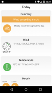
- Instantly view Airspace and weather data from your desktop or mobile device
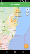
- Advanced Maps integrating real-time airspace restrictions, NOTAMs and TFRs
- Contact info for all facilities/towers/hospitals
- Total visibility of all your batteries, pilots, aircraft, and payloads
- Create, Manage, approve and Assign flights around the world
- Aviation-grade Safety Management Processes
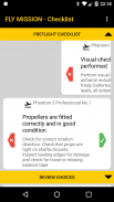
- Maintain logbooks and checklists in the field.
- Cloud storage of all records and data for instant access
- Total Auditability for risk management
- Business Intelligence to enhance future operations
- Real time FAA data sync
From the first flight of the Kittyhawk by the Wright brothers engineers have pushed the boundaries of flight. Learn to enjoy the drone hobby, don't just hover around in your back-yard. Stay compliant with your drone regulations, your dronelogbook etc without spending hours studying the drone laws.
ड्रोन संकलक -, सबसे अधिक उपयोगी सहज और बुद्धिमान ड्रोन प्रबंधन सॉफ्टवेयर उपलब्ध, पायलटों के लिए, पायलटों द्वारा बनाया गया था।
इस पार मंच समाधान का उपयोग करें तुरन्त, हवाई क्षेत्र और मौसम, योजना उड़ानों जाँच विमान, बैटरी और पायलटों का प्रबंधन, और सुनिश्चित करें कि आप स्थानीय नियमों और प्रलेखन आवश्यकताओं के अनुपालन कर रहे हैं।
ड्रोन संकलक ऑस्ट्रेलिया के नागरिक उड्डयन सुरक्षा प्राधिकरण (सीएएसए) द्वारा चयनित किया गया था उनके राष्ट्रीय "मैं वहाँ फ्लाई कर सकते हैं" अनुप्रयोग प्रदान करने के लिए।
ड्रोन संकलक अपने व्यापार एक तत्काल प्रतिस्पर्धात्मक लाभ देता है:
- तुरंत अपने डेस्कटॉप या मोबाइल डिवाइस से एयरस्पेस और मौसम डेटा को देखने के
- उन्नत नक्शे वास्तविक समय हवाई क्षेत्र प्रतिबंध, NOTAMs और TFRs एकीकृत
- सभी तरह की सुविधाएं / टावरों / अस्पतालों के लिए संपर्क जानकारी
- सभी अपनी बैटरी, पायलट, विमान, और पेलोड के कुल दृश्यता
- बनाने, प्रबंधित करने को मंजूरी और दुनिया भर में उड़ानों निरुपित
- विमानन ग्रेड सुरक्षा प्रबंधन प्रक्रियाओं
- क्षेत्र में लाँग बुक और जाँच सूची बनाए रखें।
- त्वरित पहुँच के लिए सभी रिकॉर्ड और डेटा के बादल भंडारण
- जोखिम प्रबंधन के लिए कुल auditability
- व्यापार खुफिया भविष्य के संचालन को बढ़ाने के लिए
- वास्तविक समय एफएए डेटा सिंक
राइट भाइयों द्वारा Kittyhawk की पहली उड़ान से इंजीनियरों उड़ान की सीमाओं धक्का दिया है। ड्रोन शौक आनंद लेने के लिए जानें, बस अपने बैक यार्ड में चारों ओर मंडराना नहीं है। अपने ड्रोन नियमों, कानूनों का अध्ययन ड्रोन घंटे खर्च किए बिना अपने dronelogbook आदि के अनुरूप रहें।


